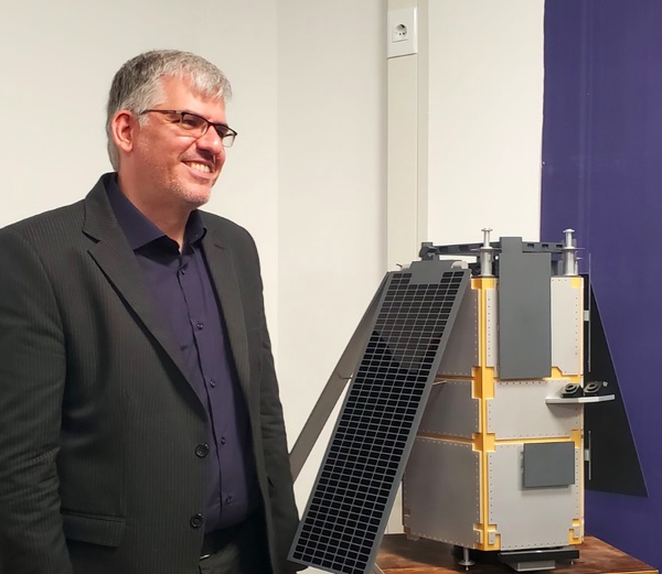
 Hassan Salarieh, the head of the Iranian Space Agency, poses next to a model of the Russian-built Khayyam remote sensing satellite. |
Russia and Iran expand space cooperation
by Bart Hendrickx
Monday, October 31, 2022
Russia and Iran are gradually expanding their cooperation in space, but doing so without much fanfare. Last August, a Russian-built remote sensing satellite for Iran was launched from the Baikonur Cosmodrome and three more are expected to follow in the coming years. There is also compelling evidence that a Russian company is building a communications satellite for Iran that will be placed into geostationary orbit in 2024. Russia’s efforts to keep the details of these projects under wraps, though, have been largely ineffective.
Khayyam
In August 2015, Iran reached a preliminary agreement with two Russian companies on the launch of a Russian-built remote sensing satellite to be operated by Iran. The leading role in the project on the Russian side was assigned to NPK Barl, which was also responsible for integrating and finishing the ground-based infrastructure. The satellite would be designed and built by the VNIIEM Corporation, which has a long history of developing meteorological and remote sensing satellites.
| In animation of the launch following the jettisoning of the payload shroud, the satellite was depicted as a featureless box-shaped object. The Iranians had fewer qualms about depicting the satellite. |
The news was widely reported in the Russian media at the time, but in the following years the project went into a virtual news blackout, raising doubts if an actual contract had been signed. The status of the project finally became clear in February 2021. Speaking during a virtual roundtable discussion organized by Russia’s upper house of parliament, a representative of NPK Barl disclosed that the launch of a remote sensing satellite for “a foreign customer” was set for the second quarter of the year. He did not identify that customer, despite the fact that the company had been openly linked to the Russian-Iranian project several years earlier. When President Vladimir Putin was asked to react to a story on the Iranian satellite published in the Washington Post in June 2021, he dismissed it as “fake news” and “nonsense”.[1]
The launch of the Iranian satellite eventually slipped to August 9, 2022. It was only days before the launch that Roskosmos acknowledged that the rocket’s main payload was a remote sensing satellite for Iran. Earlier reports on the scheduled launch had focused only on 16 Russian microsatellites that would go along for the ride. The launch took place from the Baikonur Cosmodrome using a Soyuz-2-1b rocket with a Fregat upper stage. The booster had originally been earmarked to orbit 36 broadband satellites for OneWeb in early March, but the launch was canceled after Russia started its so-called “special military operation” in Ukraine on February 24. The satellite was inserted into a nearly circular 500-kilometer orbit inclined 97.4 degrees to the Equator and was named Khayyam in honor of Omar Khayyam, a Persian mathematician and poet who lived in the 11th and 12th centuries.
Russian coverage of the launch was low key. Roskosmos TV broadcast the launch live with running commentary on launch milestones, but without the background reports and interviews that are usually part of its launch webcasts. The launch commentator did not mention Iran at all, closing off the webcast by confirming the successful separation of “the satellite for Project 505”, the code name for the Russian-Iranian project. In animation of the launch following the jettisoning of the payload shroud, the satellite was depicted as a featureless box-shaped object. No pictures were released of the satellite during assembly or launch preparations, a clear sign that the Russians did not wish to reveal its design to the outside world.
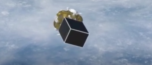 Khayyam is shown as a featureless black box attached to the Fregat upper stage in the live webcast of the launch. Source |
The Iranians had fewer qualms about depicting the satellite. A drawing of the satellite hovering above Earth appeared on a number of Iranian websites and a scale model of the satellite was on display during a press conference held one day after the launch by the head of Iran’s space agency, Hassan Salarieh.
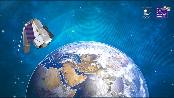 A drawing of Khayyam that appeared on several Iranian websites in the days after the launch. |
Ironically enough, the Russians themselves had inadvertently unveiled the satellite’s design and even its capabilities well before the launch. The satellite was seen in two slides shown by representatives of NPK Barl during the February 2021 virtual meeting, where it was identified only as a satellite for “a foreign customer”. Its mass was given as 650 kilograms and its linear resolution as 1.1 meters, although one of the officials added that by Western standards it is actually 0.73 meters. The satellite could cover a ground swath of 12.5 kilometers from an altitude of 500 kilometers, take pictures in spectral bands from 0.5 to 0.8 microns and send down data at speeds of 240, 480, and 720 megabits per second.[2]
More information on Khayyam’s design could be gleaned from a patent published by NPK Barl in August 2021.[3] This describes a high-resolution remote sensing satellite looking exactly like Khayyam. It has a hexagonally shaped bus and four solar panels extending downwards at a 45-degree angle to the satellite’s longitudinal axis.
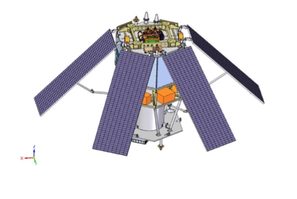 Khayyam as depicted in a patent published by NPK Barl. Source |
The payload is a Korsch telescope with what are called five “optical elements”. A Korsch telescope is a compact three-mirror anastigmat telescope offering a wide field of view. The telescope provides imaging in one panchromatic channel and four multispectral channels (near infrared, red, green, and blue). Three possible configurations are given for the telescope, all with a focal ratio of f/11.53 (the focal ratio being the focal length divided by the aperture). The values for the three configurations are:
| Aperture | Focal length |
|---|---|
| 0.535 m | 6.17 m |
| 0.75 m | 8.65 m |
| 1.1 m | 12.68 m |
In the first configuration, shown in the drawing below, the telescope weighs 125 kilograms and is 1.8 meters long.
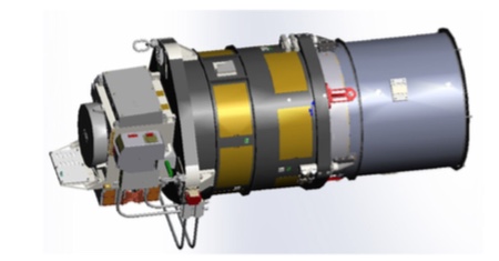 |
The other two configurations result in a longer bus, but don’t require any changes to the payload’s electronics boxes and CCD pixel arrays. The telescope uses a spherical rather than a flat focal array to help prevent smearing of the images. An electronically scanned array sends back data to the ground in the X-band at speeds ranging from 480 megabits to 1.5 gigabits per second (a higher rate than reported by NPK Barl in February 2021).
The manufacturer of the optical payload is not known, but could be NPK Barl itself, despite its specialization in ground-based systems. During an exhibition in 2019 the company exhibited a remote sensing telescope that was expected to fly into space within the next two years. It was reported to have a mass of just 46 kilograms and also looks smaller than the one in the patent, but the only possible host satellite that can be identified for it right now is Khayyam. Possibly, only one section of the telescope was put on display.[4]
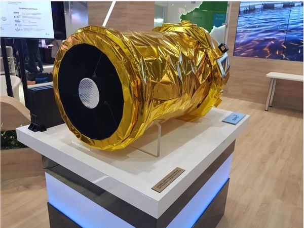 Telescope displayed by NPK Barl in 2019. Source |
In one of the drawings accompanying the patent, the satellite sits atop the Fregat upper stage inside the payload shroud of a Soyuz-2-1a rocket (indicating that this was the originally planned launch vehicle instead of the heavier Soyuz-2-1b). Although patents rarely refer to the projects they are related to, the satellite is actually indicated here as belonging to Project 505. As seen in another drawing, the satellites are small enough for three of them to fit inside the nose fairing.
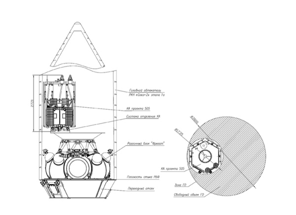 Khayyam in its launch configuration. Source |
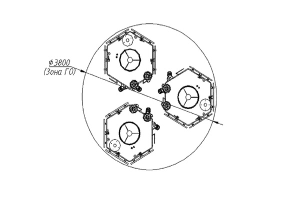 Three Khayyam type satellites inside the payload shroud. Source |
Khayyam may be identical to, or inherit design features from, a small optical reconnaissance satellite that VNIIEM is building for Russia’s Ministry of Defense under the name Razbeg. That would explain why the Russians themselves did not release any images of the satellite after the launch (none of the ones shown in the Iranian media appeared in Russian news reports on the launch). The fact that the satellite described in the patent can accommodate three differently sized telescopes is another indication that it may not be custom-built for Iran. In addition to that, VNIIEM is far less secretive about an imaging satellite (RBKA) that it will launch for Belarus and which does appear to have a unique design.
| Russia was planning to use Khayyam for several months or longer to enhance its surveillance of military targets in Ukraine before turning it over to Iran. |
The Razbeg project officially got underway in November 2016 with a contract signed between the Ministry of Defense and VNIIEM. News reports on the Russian-Iranian satellite deal in 2015 said the satellite would be based on VNIIEM’s Kanopus remote sensing satellites, which weigh around 470 kilograms and have cameras with a resolution of 2.5 and 12 meters. Those plans clearly changed in the following years, possibly because it was decided to unify the Iranian satellite’s design with that of Razbeg and thereby offer the Iranians a more capable satellite with a significantly higher resolution.
So far there are only two known links between Khayyam and Razbeg. As can be learned from procurement and court documents, both satellites use the same type of star sensor and at least part of the ground segment for both is provided by NPK Barl.[5] A high-resolution VNIIEM satellite shown in a presentation of Roskosmos’ R&D institute TsNIIMash around 2016–2017 looks somewhat similar to Khayyam, but it is smaller (weighing just 450 kilograms) and in addition to panchromatic and multispectral cameras (with resolutions of 0.7 and 2.0 meters) also has an infrared payload (with a resolution of 3–5 meters). It is unclear if it bears any relation to Razbeg or an experimental precursor of that satellite launched as Kosmos-2525 (also known as EMKA) in March 2018.
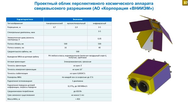 High-resolution imaging satellite of VNIIEM. Source |
Despite some rumors to the contrary, Razbeg has most likely not flown yet. Last June an official of VNIIEM reported that three satellites known as MKA 1, 2, and 3 were expected to be launched in the second half of the year.[6] MKA, an abbreviation standing for “small satellite”, is used as a cover name for a military satellite, possibly Razbeg. If the two projects are indeed related, Khayyam could serve as a testbed for the new Russian reconnaissance satellites. The three MKA satellites may be launched together by a single Soyuz-2 rocket, flying in the configuration seen in the NPK Barl patent. So far, however, there are no indications that any such launch is planned before the end of the year.
Officially, Khayyam will have only civilian applications in such fields as agriculture, natural resources management, and environmental monitoring. Shortly after launch, the head of Iran’s space agency claimed Khayyam cannot be used as a spy satellite because of its small size. However, its reported ground resolution (0.73 meters) would be more than sufficient to do valuable reconnaissance work. The possible civilian and military applications of Khayyam were summed up in an infographic released by the Iranian Military Studies and Analysis Institute, which appears to be an independent Iranian think tank, so the information should not be considered official.
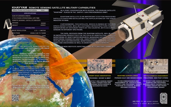 Infographic on Khayyam’s targets of observation compiled by the Iranian Military Studies and Analysis Institute. Source |
According to an article published in the Washington Post on August 4, Russia was planning to use Khayyam for several months or longer to enhance its surveillance of military targets in Ukraine before turning it over to Iran. The newspaper cited two Western security officials who spoke on the condition of anonymity because of sensitivities surrounding intelligence collection.[7] Tehran, which denies that the satellite is being used for military purposes at all, strongly denied the claim. It said that Khayyam’s mission control center and data acquisition stations are located only on Iranian territory and that the satellite receives commands and returns data using encrypted algorithms developed by Iranian specialists. The Iranians were also quick to point out that they began receiving telemetry from the satellite on the very first day of its mission.
According to Iranian news reports, Khayyam’s mission control center is located at the Mahdasht Space Center, which is roughly 60 kilometers west of Tehran, not far from the city of Karaj. The center was established back in the early 1970s to receive data from foreign remote sensing satellites, the first being the US Landsat satellites. As can be seen in Google Earth imagery, construction of a new building at the site began around April 2020 and is now complete. Two parabolic antennas just northeast of the new building are presumably seen in an Iranian TV report aired from the mission control center after Khayyam’s launch.
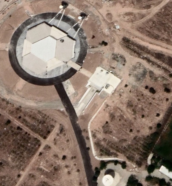 Recent Google Earth image of what likely is Khayyam’s mission control center about 60 km west of Tehran. The coordinates are 35.766787°N, 50.785668°E. |
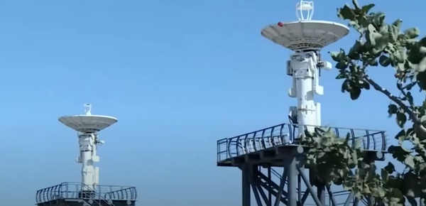 Two parabolic antennas near Khayyam’s control building at the Mahdasht space center. Source |
The Washington Post reported in June 2021 that Russian specialists had traveled to the facility in the spring of that year to help train ground crews that would operate the satellite. It is not clear if Mahdasht also acts as a data reception facility, but that is what the center was originally built for and the 2021 NPK Barl patent mentioned the possibility of concentrating the mission control and data acquisition functions in a single place. The patent also describes remotely operated control and data reception facilities that would be connected to mission control via ground lines or Ka/Ku-band satellite channels. These would make it possible to maximize the number of communication sessions with the satellite as well as its data output.
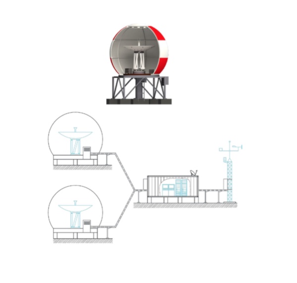 Remotely operated ground station for Khayyam. Source |
If the ground segment that NPK Barl has built for Khayyam and Razbeg is similar, it is not inconceivable that the Russians can directly pick up data from the satellite from their own territory. But even if the Iranians have the exclusive right to receive the satellite’s data, that still wouldn’t stop them from sharing images with Russia. Although Iran has not openly voiced its support for Russia’s military operation in Ukraine, there is strong evidence that it has been supplying Russia with surveillance and kamikaze drones to assist it in its war effort.
Any additional imagery of the conflict zone in Ukraine would be more than welcome for Russia, which currently operates only two high-resolution optical reconnaissance satellites of the Persona type (Kosmos-2486 and 2506). These have been in orbit since 2013 and 2015 respectively and have almost certainly exceeded their design lifetime. The launch of two big next-generation spy satellites (Razdan) is years behind schedule.[8]
Khayyam, which is expected to operate for at least five years, is supposed to be joined by more satellites in the coming years. After the launch, Hassan Salarieh announced that Iran had ordered three more satellites of the same type, adding that the first satellite had cost a total of $40 million.
Ekvator
It looks like space co-operation between Russia and Iran is now also moving beyond the field of remote sensing. Evidence has emerged in recent weeks that Russia is building a geostationary communications satellite for Iran under the name Ekvator (Russian for “equator”). The name first appeared in 2020 in a brief biography of a specialist of ISS Reshetnev, Russia’s leading producer of communications satellites based near Krasnoyarsk in Siberia. It was mentioned alongside many other projects that this person had been involved in and no additional details were given.[9]
| Evidence has emerged in recent weeks that Russia is building a geostationary communications satellite for Iran under the name Ekvator (Russian for “equator”). |
Ekvator again showed up in tender documentation placed online in March this year.[10] This contained information on a contract to study the environmental impact of the Ekvator launch, which is to be carried out from the Baikonur Cosmodrome with a Proton-M rocket and a Briz-M upper stage. The rocket burns toxic hypergolic propellants and drops its first and second stages over Kazakhstan and the Altai mountain range. The contract on the environmental study was signed between Glavkosmos Launch Services and the Moscow State University of Geodesy and Cartography (MIIGAiK) and in turn was based on a contract concluded between ISS Reshetnev and Glavkosmos Launch Services on April 12, 2021.
Glavkosmos is a daughter company of Roskosmos charged with marketing Russian space industry products on the global market. Glavkosmos Launch Services was set up under Glavkosmos in 2017 to arrange commercial launches of the Soyuz-2 rocket from Russian spaceports. In 2019 Glavkosmos took control of International Launch Services (ILS), which until then had had the exclusive right to sell Proton launches on the international market. Under the management of Glavkosmos, ILS and Glavkosmos Launch Services would offer Soyuz and Proton missions in parallel, with ILS taking a leading role in sales in the North American market.[11]
The involvement of Glavkosmos Launch Services as well as the secrecy surrounding the payload were a clear indication that Ekvator was being built for a foreign partner that Russia did not wish to disclose. However, the documentation did not make it possible to positively identify that partner or even determine the nature of the payload.
More information on the project came to light in early October, when MIIGAiK published a detailed report on the expected environmental impact of the Proton-M launch carrying Ekvator.[12] The satellite will use ISS Reshetnev’s Express-1000H platform, which has been used by various communications satellites since 2011. The report describes three Russian Express satellites (AT-1, AT-2 and AM-8) as “prototypes” of Ekvator, the main difference being the communications payload carried by the satellite. Express-1000H is described by other sources as a medium-size platform with a maximum mass of 1,900 kilograms and a maximum payload mass of 500 kilograms. However, Ekvator significantly exceeds that, with the report giving a total mass of about 2,300 kilograms and a payload mass of 755 kilograms. Two drawings of the satellite published in the report show several antennas operating in the Ka-, Ku-, and S-bands.
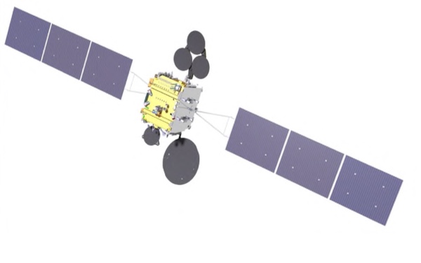 Drawings of Ekvator published in a recent environmental impact report. Source 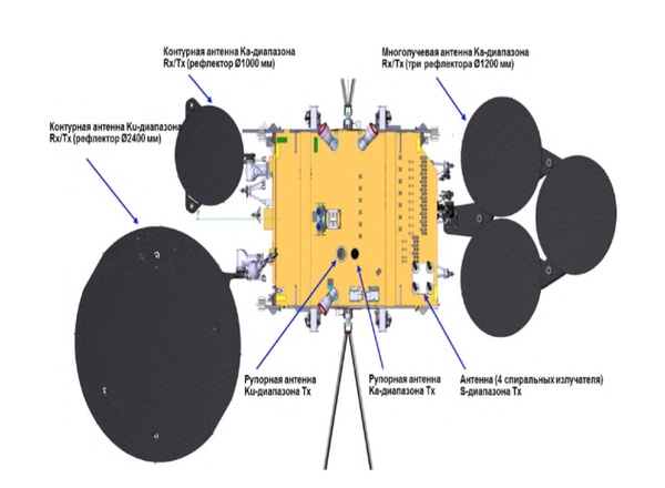 |
Also included is a drawing of the satellite in its launch configuration. Installed underneath the satellite is an adapter connecting it to the Briz-M upper stage. This will remain attached to the satellite throughout its lifetime.
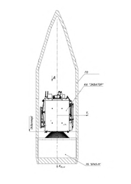 Ekvator inside the Proton-M rocket’s payload shroud. Source |
The report does not reveal who ordered the satellite, but one piece of information does make it possible to identify the operator with a high degree of certainty. In a table showing the satellite’s main technical features, its slot in geostationary orbit is given as 34 degrees east longitude. According to the website of the International Telecommunication Union (ITU), this slot is currently reserved for an Iranian communications satellite under the name IRN-30B-34E. In fact, it has belonged to Iran on and off for several decades.
Iran’s plans to purchase geostationary communications satellites abroad go back all the way to the Shah’s regime in the late 1970s. Originally known as Zohreh (“Venus”), the satellites were first supposed to be built by India and launched aboard the Space Shuttle. The Zohreh plans were shelved after the 1979 Islamic Revolution only to be resurrected about a decade later. In 1993, a tentative agreement was reached with the French companies Alcatel Espace and Aerospatiale to build two Zohreh satellites and station them at 26 and 34 degrees east, but the deal eventually fell through. Around the turn of the century, Iran set its sights on Russia to construct the satellites. In January 2005, an agreement was reached under which ISS Reshetnev would deliver the satellites later that decade (incidentally, in the same year Russia orbited Iran’s very first satellite Sina-1, a small remote sensing and communications satellite built by the Russian company PO Polyot.) However, for unclear reasons nothing came of those plans either.
| For some reason, Russia and Iran are treating their partnership in space as an inconvenient truth. |
A handful of press reports suggest that around the middle of last decade the Iranians again began looking for foreign partners to build one or more communications satellites. In October 2016, Iran’s Communications and Information Technology Minister Mahmoud Vaezi said that satellite manufacturers from four countries (China, France, Russia, and South Korea) had expressed interest in building what he called Iran’s National Communications Satellite.[13] No foreign partner had been selected yet in February 2019, when Vaezi’s successor, Mohammad Javad Azari Jahromi, told reporters that the purchase of a geostationary communications satellite was still in the planning stage.[14] Although no official announcements were made, Iran seems to have reached a deal with Russia on the purchase of the satellite sometime between then and early 2021, when ISS Reshetnev signed its contract with Glavkosmos to provide launch services for Ekvator.
In March 2017, the Iranian space agency announced that it had applied to the ITU for five geostationary orbital slots for Ka- and Ku-band communications satellites.[15] Operators have a limited time period to place satellites in such orbital slots before they need to re-apply for them. This is what Iran seems to have done, because the five slots are still assigned to it in the latest ITU listings. They are:
| 24°19E | IRN-24.19E |
| 24°19 E | IRN-30B-24.19E |
| 26° E | IRN-30N-26E |
| 34° E | IRN-30B-34E |
| 43.5°E | IRN-30B-43.5E |
Ekvator (which may well receive a name in Farsi after it is launched) is supposed to occupy the 34°E slot within the next two years. According to the MIIGAiK environmental report, it is scheduled for launch in the first quarter of 2024. The satellite will probably be used for a mix of civilian and military purposes. Such goals had also been announced for its unflown predecessor Zohreh.
Iran eventually intends to launch geostationary communications satellites using indigenous launch vehicles, but it doesn’t look like any that will be fielded in the foreseeable future will be capable of putting a meaningful payload into that kind of orbit. Therefore, the country is likely to rely on Russia to fill the remaining slots as well. If any deals on this exist yet, they have been made behind closed doors. For some reason, Russia and Iran are treating their partnership in space as an inconvenient truth.
References
- For an analysis of information collected on the Russian-Iranian satellite by June 2021 see: B. Hendrickx, “Scrutinizing the Russian-Iranian satellite deal”, The Space Review, June 21, 2021.
- More information on NPK Barl’s February 2021 presentations is in reference 1.
- Patent (in Russian with English abstract) published by NPK Barl in August 2021.
- The telescope was on display at an exhibition held in Tver in February 2019. Details were given in a Russian TV report that is no longer available online.
- NPK Barl’s role in Razbeg is revealed in court documentation (in Russian) placed online in late 2021 and early 2022. Mentioned in the documents is work on a part of the project named Razbeg-NS-SPI-APK, where “NS” most likely stands for “ground segment”.
- The plans for launching the three MKA satellites were mentioned in a VNIIEM presentation that was temporarily online earlier this year.
- J. Warrick, E. Nakashima, “Russia to launch spy satellite for Iran but use it first over Ukraine”, The Washington Post, August 4, 2022.
- B. Hendrickx, “Upgrading Russia’s fleet of optical reconnaissance satellites”, The Space Review, August 10, 2020.
- Biography (in Russian) of ISS Reshetnev specialist Mikhail Matylenko.
- Tender documentation (in Russian) placed online in March 2022.
- S. Clark, “Proton launch provider ILS embraces closer relationship with Roscosmos”, Spaceflight Now, May 17, 2019.
- Environmental impact report (in Russian) published by the Moscow State University of Cartography and Geodesy, 2022.
- Four countries interested in building Iran’s national communication satellite, SpaceWatch, October 2016.
- Mehr news agency report, February 25, 2019.
- Iran space agency applies for five geostationary orbital slots for Ka- and Ku-band communications satellites, SpaceWatch, March 2017.
Note: we are using a new commenting system, which may require you to create a new account.
No comments:
Post a Comment